Dubai Metro Map 2027: A Complete Guide To PDF, Station Numbers, New Updates, Red Line And Blue Line
Dubai Metro Map. Dubai is a city known for its modern infrastructure, skyscrapers, and smooth transport system. One of the key reasons for Dubai’s efficient commuting is the Dubai Metro. Since its launch in 2009, the Dubai Metro has been transforming how people move across the city.
Whether you are a tourist or a resident, understanding the Dubai Metro Map, its lines, stations, and timings is essential for a smooth journey.
In this guide, we will cover everything you need to know about the Dubai Metro Map PDF, Dubai Metro map with number, new updates, Red Line, Blue Line, and Green Line, along with tips, fares, and station details.
What is Dubai Metro?
The Dubai Metro is a modern, driverless metro system operated by the Roads and Transport Authority (RTA). It is designed to provide fast, safe, and eco-friendly travel for everyone in Dubai. The Metro not only connects residential and commercial areas but also iconic landmarks, shopping malls, and business districts.
Currently, Dubai Metro features:
- Red Line: Covers Dubai’s main highway and key locations from Centrepoint to Expo City.
- Green Line: Serves historical and cultural parts of Dubai, connecting residential and business areas.
- Blue Line (Under development): Will further expand connectivity to residential zones and business hubs.
With over 80 kilometers of track and dozens of stations near major attractions, Dubai Metro is now a backbone of city transportation.
Why Dubai Metro is Popular
The Dubai Metro is more than just a train. It has become the city’s favorite for many reasons:
- Time-Saving: Avoid traffic and reach your destination faster.
- Eco-Friendly: Reduces road congestion and carbon emissions.
- Comfortable: Fully air-conditioned trains with modern facilities.
- Safe: CCTV monitoring, security staff, and emergency protocols.
- Accessible: Elevators, ramps, wide gates, and facilities for people with disabilities.
Dubai Metro Map PDF
Dubai Metro Lines and Routes
Understanding the Dubai Metro Map is important for planning your travel. Here’s a detailed breakdown of all operational and upcoming lines.
Red Line
The Red Line is the most popular line, running along Sheikh Zayed Road and connecting key locations. Some highlights include:
- Centrepoint Station: Near Dubai International Airport
- Burj Khalifa/Dubai Mall: Gateway to Downtown Dubai
- Mall of the Emirates: Perfect for shoppers
- Dubai Marina: Coastal lifestyle hub
- Expo City: Site of Expo 2020 and future developments
Red Line Station List
| Station Code | Station Name |
|---|---|
| R11 | Centrepoint |
| R12 | Emirates |
| R13 | Airport Terminal 3 |
| R14 | Airport Terminal 1 |
| R15 | GGICO |
| R16 | City Centre Deira |
| R17 | Al Rigga |
| R18 | Union |
| R19 | BurJuman |
| R20 | ADCB |
| R21 | Max |
| R22 | World Trade Centre |
| R23 | Emirates Towers |
| R24 | Financial Centre |
| R25 | Burj Khalifa/Dubai Mall |
| R26 | Business Bay |
| R29 | Onpassive |
| R31 | Equiti |
| R32 | Mall of the Emirates |
| R33 | Mashreq |
| R34 | Dubai Internet City |
| R35 | Al Khail |
| R36 | Sobha Realty |
| R37 | DMCC |
| R38 | Jebel Ali |
| R39 | Ibn Battuta |
| R40 | Energy |
| R41 | Danube |
| R42 | UAE Exchange |
| R70 | The Gardens |
| R71 | Discovery Gardens |
| R72 | Al Furjan |
| R73 | Jumeirah Golf Estates |
| R74 | Dubai Investment Park |
| R76 | Expo 2020 |
Green Line
The Green Line runs through Dubai’s historic and cultural areas, including neighborhoods along Dubai Creek.
Green Line Highlights
- Etisalat Station: Northern terminus serving residential areas
- Al Ghubaiba: Close to Dubai Creek and traditional souks
- Union Station: Major interchange with Red Line
- Creek Station: Offers scenic views of Dubai Creek
Green Line Station List
| Station Code | Station Name |
|---|---|
| G11 | Etisalat |
| G12 | Al Qusais |
| G13 | Dubai Airport Free Zone |
| G14 | Al Nahda |
| G15 | Stadium |
| G16 | Al Qiyadah |
| G17 | Abu Hail |
| G18 | Abu Baker Al Siddique |
| G19 | Salah Al Din |
| G20 | Union |
| G21 | Baniyas Square |
| G22 | Gold Souq |
| G23 | Al Ras |
| G24 | Al Ghubaiba |
| G25 | Sharaf DG |
| G26 | BurJuman |
| G27 | Oud Metha |
| G28 | Dubai Healthcare City |
| G29 | Al Jadaf |
| G30 | Creek |
Transfers between Red Line and Green Line are easy at Union and BurJuman stations.
Blue Line (Upcoming)
The Blue Line will enhance connectivity in Dubai with 14 new stations.

Blue Line Key Stations
- Bur Dubai
- Deira
- Downtown
- Business Bay
- Dubai Marina
- Jumeirah Beach Residence
- Expo City
New Blue Line Stations
| S.N. | Station |
|---|---|
| 1 | Dubai Creek Harbour |
| 2 | Dubai Festival City |
| 3 | Ras Al Khor |
| 4 | Dubai International City 2 & 3 |
| 5 | Dubai Silicon Oasis |
| 6 | Academic City |
| 7 | Metro Depot Al Ruwayyah 3 |
| 8 | Dubai International City 1 |
| 9 | Al Warqaa |
| 10 | Mirdif City Centre |
| 11 | Al Rashidiya |
The Blue Line will run on consistent timings with minimal wait times and provide state-of-the-art facilities, including seating, ramps, restrooms, and prayer rooms.
Dubai Metro Fares and Nol Card
The Dubai Metro uses a cashless payment system called the Nol Card. It is simple and convenient for daily commuters.
Nol Card Options
- Silver Card: Ideal for regular travel
- Gold Card: Access to Gold Class cabins
- Red Ticket: Short-term visitors
- Personalized Card: For frequent travelers
Fares start at AED 3 depending on zones traveled. You can recharge your card at machines, online, or service centers.
Dubai Metro Timings
The Dubai Metro operates seven days a week. Trains run every 2–3 minutes during peak hours and every 5–7 minutes during non-peak hours.
| Day | First Train | Last Train |
|---|---|---|
| Monday to Thursday | 05:00 AM | 12:00 AM |
| Friday | 05:00 AM | 01:00 AM (Next Day) |
| Saturday | 05:00 AM | 12:00 AM |
| Sunday | 08:00 AM | 12:00 AM |
Note: First and last train timings may vary by station.
Tips for Using Dubai Metro
- Avoid traveling during peak hours (7–9 AM, 5–7 PM).
- Use Women & Children cabins if traveling with family.
- Always keep your Nol card ready before entering.
- No eating, drinking, or chewing gum on trains.
- Plan your route using the RTA Journey Planner.
Connections Beyond Metro
The Dubai Metro is integrated with other transport systems:
- Feeder buses: Connect deeper neighborhoods
- Dubai Tram: Links Dubai Marina to Al Sufouh
- Marine transport: Water buses and abras for scenic routes
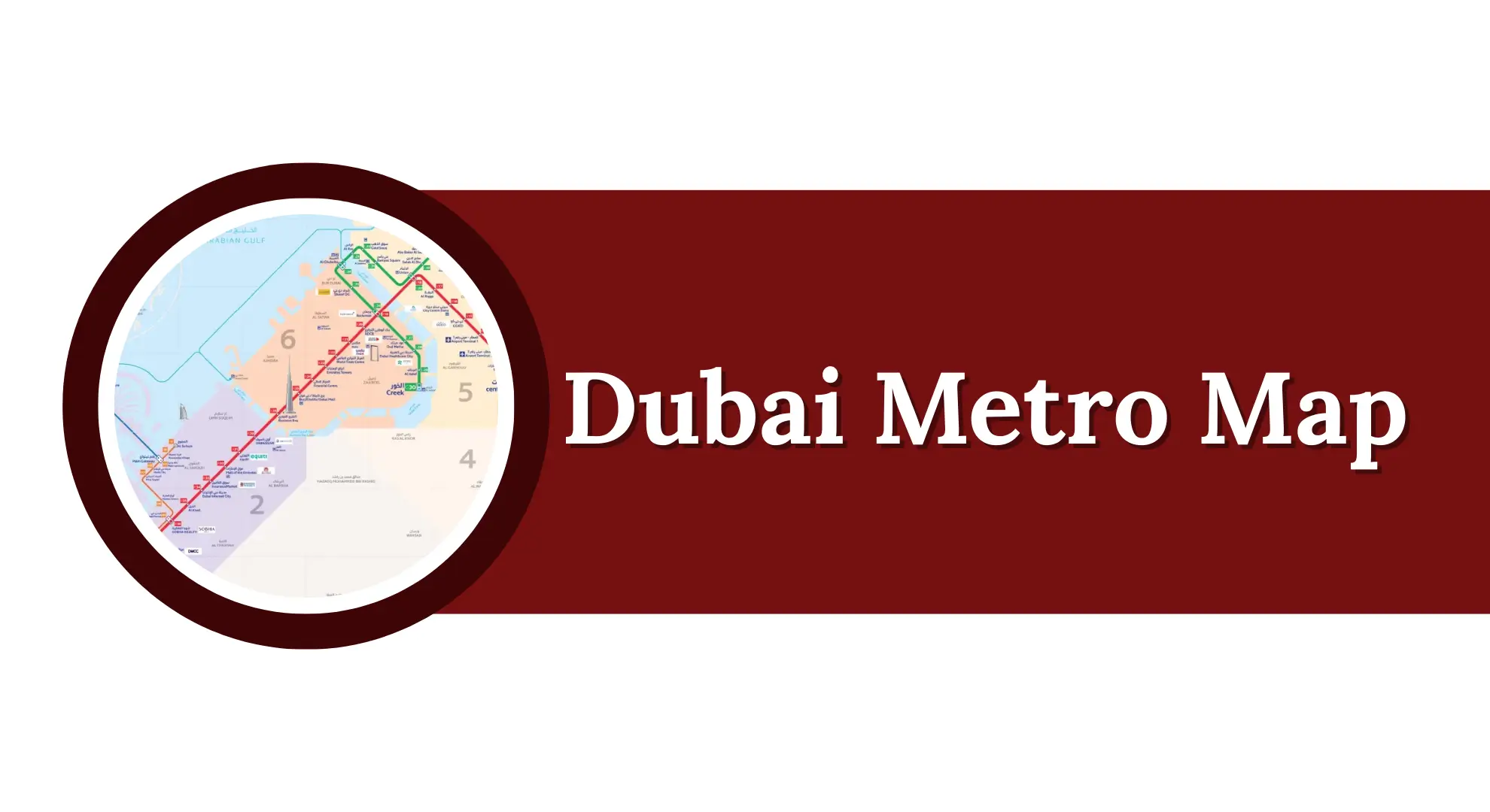
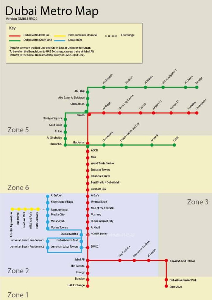
Dubai Metro Map PDF & Numbered Map
The Dubai Metro Map PDF is available at all stations and online. It shows:
- Line colors (Red, Green, Blue)
- Station codes and numbers
- Interchange stations
- Nearby attractions
This makes navigation easy for both tourists and residents.
Schematic Map
Updated Station Names
Several stations have been renamed for clarity or sponsorships:
- Al Fahidi → Sharaf DG
- Al Jafiliya → Max
- Al Karama → ADCB
- DAMAC Properties → Dubai Marina / SOBHA Realty
- Jebel Ali → UAE Exchange
- First Abu Dhabi Bank → Umm Al Sheif
- Jumeirah Lakes Towers → DMCC
- Khalid Bin Al Waleed → BurJuman
- Nakheel → Al Khail
- Nakheel Harbour & Tower → Jebel Ali
- Noor Bank → Al Safa
- Palm Deira → Gold Souq
- Rashidiya → Centrepoint
Why You Should Use Dubai Metro
- Affordable: Single journey tickets start at AED 3
- Fast & Efficient: Avoid traffic and reduce commute time
- Comfortable & Modern: Clean, air-conditioned, and fully monitored
- Eco-Friendly: Reduces carbon footprint of city travel
- Accessible: Facilities for all, including ramps and elevators
FAQs About Dubai Metro Map
What is the Dubai Metro Map PDF and how can I download it?
Ans: The Dubai Metro Map PDF is a complete map showing all stations, lines, and interchanges. You can download it from the RTA official website or find it at any Metro station. It helps plan your route easily.
How many lines does the Dubai Metro have?
Ans: Currently, Dubai Metro has two operational lines:
- Red Line
- Green Line
The Blue Line is under development and will add more connectivity across the city.
What is the Dubai Metro map with number?

Ans: A Dubai Metro map with numbers shows station codes along each line (like R11, G20). This helps travelers identify stations quickly, especially at interchanges and major destinations.
What are the timings of the Dubai Metro?
Ans:
- Monday to Thursday: 5:00 AM – 12:00 AM
- Friday: 5:00 AM – 1:00 AM (Next Day)
- Saturday: 5:00 AM – 12:00 AM
- Sunday: 8:00 AM – 12:00 AM
Trains run every 2–3 minutes during peak hours and every 5–7 minutes during non-peak hours.
How much does it cost to travel on Dubai Metro?
Ans: The fare depends on the zones you travel:
- Single journey: AED 3 – AED 7.50
- Nol Cards: Silver, Gold, Red Ticket, and Personalized options make commuting easy and cashless.
What are the main Red Line stations in Dubai Metro?
Ans: Key Red Line stations include: Centrepoint, Burj Khalifa/Dubai Mall, Mall of the Emirates, Dubai Marina, and Expo City.
What are the main Green Line stations in Dubai Metro?

Ans: Important Green Line stations include: Etisalat, Union, Al Ghubaiba, Baniyas Square, and Creek.
When will the Blue Line of Dubai Metro be operational?
Ans: The Blue Line is currently under development. It will feature 14 new stations connecting areas like Dubai Creek Harbour, Dubai Festival City, Academic City, and Expo City Dubai.
Can I transfer between lines in Dubai Metro?
Ans: Yes. Transfers are easy at Union and BurJuman stations, where you can switch between Red and Green Lines. The Blue Line will also have interchanges with Red and Green Lines.
Conclusion
The Dubai Metro Map is your ultimate guide to traveling efficiently in Dubai. Whether you’re using the Red Line, Green Line, or the upcoming Blue Line, the Metro provides convenient, fast, and safe travel for residents and tourists alike.
About The Author